



Floods and Landslides Kill 62 Across Sumatra; Thousands Displaced
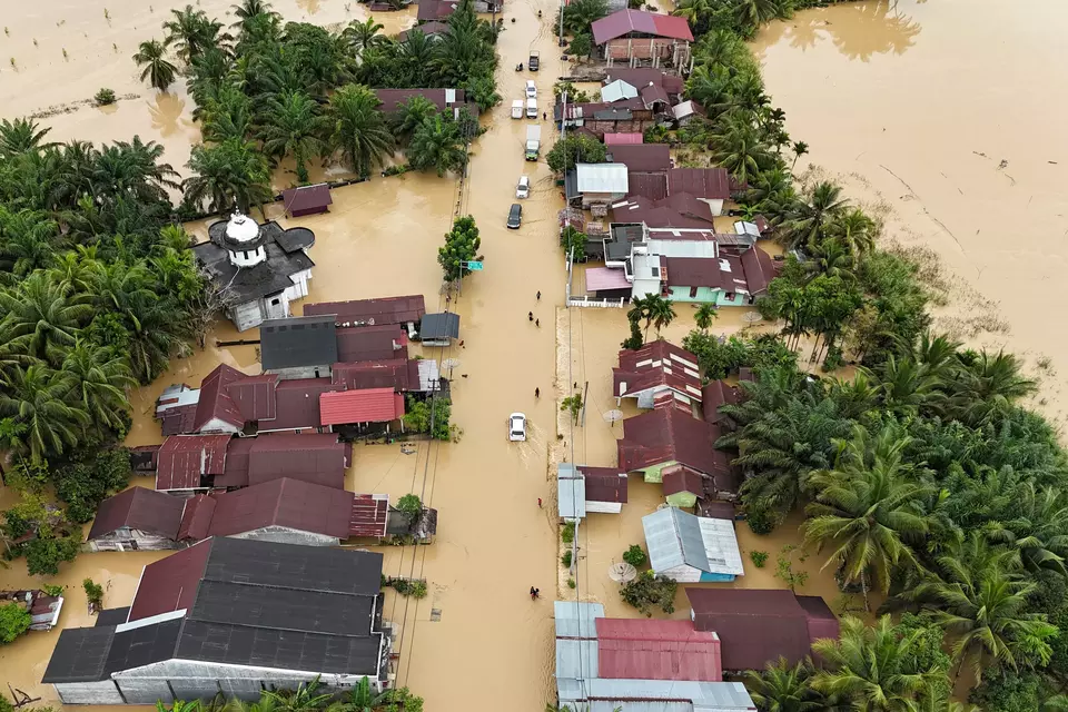
Medan. Severe floods and landslides across the Indonesian island of Sumatra have left at least 62 people dead and displaced thousands of residents over the past three days, according to updated figures released by local authorities on Thursday.
The worst impact has been recorded in North Sumatra, which reported 37 fatalities. The hardest-hit areas include:
- South Tapanuli — 17 dead
- Sibolga — 8
- Central Tapanuli — 4
- Humbang Hasundutan — 4
- Pakpak Bharat — 2
- South Nias — 1
- Padangsidimpuan — 1
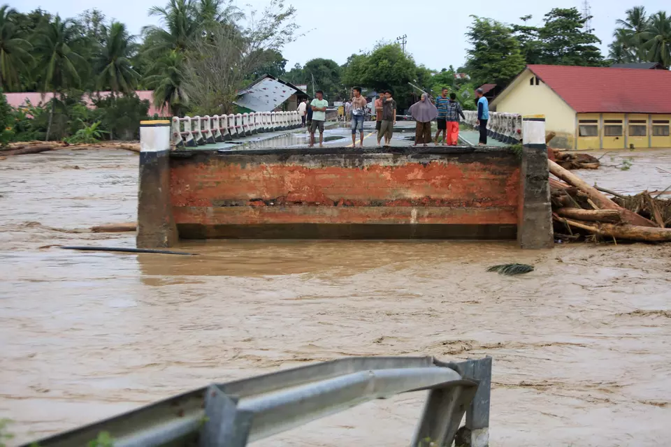
In West Sumatra, 12 more deaths were confirmed, including four in Sungai Minturun, Padang, where overflowing river currents carried mud and uprooted logs into surrounding neighborhoods, said Abdul Muhari, spokesperson for the National Disaster Mitigation Agency (BNPB).

In Bener Meriah Regency, Aceh, flash floods and landslides have struck several districts since Wednesday, leaving 13 people dead and 12 others missing. The head of the Bener Meriah Communications and Information Agency, Ilham Abdi, said communication networks are down and electricity has been cut across most affected areas.
“The situation in Bener Meriah is very alarming. Communication is down, the power is out, and several areas are inaccessible. We are still trying to reach all disaster locations,” Ilham told state radio RRI on Thursday.

Persistent Floods
Floodwaters in Medan and Deli Serdang remained high as of Thursday morning, with the Deli and Belawan rivers continuing to overflow, submerging residential areas under nearly three meters of water in some locations.
Combined rescue teams are still conducting large-scale evacuations, as many residents remain trapped inside their homes. Flooded roads have left hundreds of vehicles stalled, especially after motorists attempted to drive through high water.
Emergency personnel from the Regional Disaster Mitigation Agency (BPBD), National Search and Rescue Agency, military, and police evacuated residents using inflatable boats in Medan Maimun, one of the worst-affected districts located along the Deli River.
In Sei Mati, about 300 families have already evacuated as water levels continue to rise. Children and elderly people are being prioritized for relocation to temporary shelters.

Rescue operations are also underway in several other districts across Medan, while Deli Serdang’s Helvetia village in Sunggal faces similar conditions, with homes inundated by up to two meters of water, forcing residents to take shelter in nearby mosques.
Local resident Anto said his home began flooding at 8:00 a.m. with ankle-deep water, but levels rose to nearly two meters by late afternoon, destroying furniture.

“What we need most are food, clean water, and clothing. No assistance has arrived yet. We hope the government comes soon,” he said.
Floods also reached Jalan Kapten Sumarsono, where one meter of water caused hundreds of motorbikes to stall, forcing residents to push their vehicles to safety.

Residents in Medan and Deli Serdang are hoping the rain stops soon so the floodwaters can recede and they can return home. Local disaster agencies have not yet released official figures on the total number of displaced people, but thousands of houses are believed to be underwater and hundreds of families have evacuated.
Why Floods Keep Reoccurring in Sumatra
Flooding and landslides are seasonal disasters in Sumatra, and experts warn the situation has worsened in recent years due to a combination of natural and human-driven factors.
1. Intense Rainfall Driven by Monsoon and Climate Patterns
Sumatra lies directly along the equatorial monsoon track, making it highly vulnerable to prolonged heavy rainfall.
In recent years, La Niña cycles and Indian Ocean Dipole anomalies have intensified rainfall events.
2. Overflowing Rivers and Watersheds Under Pressure
The island is home to large river basins such as the Deli, Belawan, Batang Arau, and Musi.
When rain persists for several days, these watersheds quickly overflow, submerging low-lying settlements.
3. Deforestation and Land Conversion for Agriculture & Mining
Environmental groups have documented extensive clearance of upstream rainforest areas for:
- Agriculture and plantations
- Mining concessions
- Industrial expansion
The loss of vegetation reduces the soil’s ability to absorb water, increasing runoff and mudslide risk.
4. Rapid Urbanization Without Adequate Drainage
Major cities such as Medan and Padang have expanded faster than drainage and waste-management infrastructure.
Blocked drainage channels and riverbanks narrowed by settlement construction make floodwaters rise rapidly.
5. Poor Riverbank Management and Sedimentation
Riverbeds in many areas have shallowed due to sediment buildup, decreasing water capacity.
Illegal dumping and construction close to riverbanks further reduce river flow.
 as a preferred
Related Articles

KPK Detains 14, Seizes Cash and Gold in Disaster Agency Corruption Probe
KPK detains 14 people, including a senior BNPB official, and seizes Rp 1.4 billion in cash and gold in a corruption probe.
Japan’s Fire Aid Helicopters to Arrive in Indonesia This Week
Japan will send three CH-47 Chinook helicopters to Indonesia's fire aid.
Indonesia Has 735 Hectares of Peatland Fires Still Burning, BNPB Says
About 735 hectares of peatland remain on fire in six Indonesian provinces, with authorities warning that fires can reignite underground.
Indonesia Uses Weather Modification to Clear Volcanic Ash From Anak Krakatau
Indonesia launches a weather modification operation to reduce volcanic ash from Mount Anak Krakatau affecting Java and Sumatra.
Indonesia Wildfires: Govt Prepares Additional Disaster Funds
Indonesia says it is ready to provide additional funding for the Kalimantan forest fire response.
Eastern Indonesia Earthquake Death Toll Rises to 105
The death toll from a powerful earthquake in Indonesia’s East Nusa Tenggara province has risen to 105, with 179,037 people displaced.
Indonesia Deploys 52 Aircraft to Battle Forest Fires Across Six Provinces
Indonesia deploys five more Air Force aircraft to Kalimantan, bringing the wildfire response fleet to 52 aircraft across six provinces.
NTT Earthquake Death Toll Rises to 71
Indonesia’s NTT earthquake death toll rises to 71 as more than 3,000 aftershocks rattle the region.
NTT Earthquake Death Toll Climbs as Strong Quakes Hit Sumatra, Sulawesi
The NTT earthquake death toll has risen to 47 as separate strong earthquakes struck North Sumatra and Central Sulawesi hours later.
Indonesia Earthquake Death Toll Rises to 14 After Magnitude 7.7 Tremor
Fourteen people have died and 13 were injured after a magnitude 7.7 earthquake struck Indonesia’s Flores island, damaging homes and public fThe Latest

Prabowo Calls Meeting on Forest Fires as Haze Reaches Jakarta, Singapore
Prabowo summons senior officials to discuss forest fires as smoke reaches Jakarta and Malaysia pushes for regional action.
Jakarta Outranks Amsterdam in Global Public Transport Survey
Jakarta climbs two places to 15th in Time Out's 2026 public transport survey, with its governor citing better network integration.
MSCI Concerns, Tighter IDX Trading Rules Send Indonesian Stocks Down 5% by Midday
Indonesian stocks plunge 5% by midday as MSCI concerns weigh on sentiment and the IDX tightens its daily downside limit to 7%.
Jakarta Prepares 367 Health Facilities as Haze Reaches the Capital
Jakarta prepares 367 health facilities to treat potential haze-related illnesses after smoke from Sumatra and Kalimantan crosses the region.
Jakarta Expands Flood Prevention With New Water Storage Ponds
Jakarta opens two East Jakarta water storage ponds as it expands flood prevention efforts through reservoirs and river normalization.Most Popular
